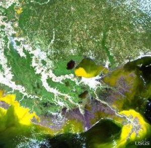
Satellite images show large amounts of sediment throughout coastal Louisiana as a result of flooding on the Mississippi River, according to recent U.S. Geological Survey and NASA data.
USGS and NASA are providing satellite imagery to the U.S. Army Corps of Engineers and the State of Louisiana to assist with the flood response efforts.

Satellite images show three large areas of sediment, or plumes, moving through the floodwaters across Louisiana. The opening of the Bonnet Carré water control structure caused a plume that is located in Lake Pontchartrain. Another plume was the combined result of the Morganza spillway being opened and flooding on the Atchafalaya River. The third plume can be seen where the Mississippi River meets the Gulf of Mexico, also known as the Mississippi Delta. This image can be found on the USGS delta website, by clicking on the sediment plume option on the right hand side.
“The current focus is the protection of life and property but we are also trying to learn more about how events like this impact the coastal ecosystems,” said Phil Turnipseed, Director of the USGS National Wetlands Research Center. “If we can better understand how sediments move into the wetlands, then we could create more effective restoration projects.”
Wetland seasonal flooding is a natural event and is essential to the health of coastal wetland ecosystems. Extreme floods deliver high amounts of sediment and nutrients to the wetlands in central and southeast Louisiana. The Atchafalaya and Wax Lake Deltas are examples of the positive effects flooding can have on a growing delta.
For more information about USGS wetlands research, visit the USGS National Wetland Research Center website.
source: USGS press release